Breaking Ground Smarter: High-Precision LiDAR Mapping for Accelerated Exploration.
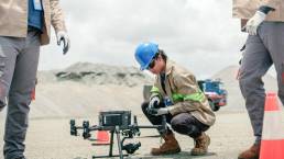
An exploration company operating in the Brokopondo region, Suriname, required accurate terrain mapping for their operations. Conventional land surveys proved impossible due to dense vegetation, creating a need for a penetrating mapping method to obtain precise terrain models. AMPS Drone Services deployed its high-resolution LiDAR mapping solution, conducting drone surveys across 470 hectares with LiDAR penetration.
Our team generated detailed terrain models, contour maps, and access routes while providing expert consultation for mine planning and site access. The results included: (1) completed terrain modeling in under one week instead of months; (2) foundational data for infrastructure development; and (3) significant cost and time savings compared to manual surveys. We demonstrated its value as a strategic partner for mining companies needing reliable data in challenging environments. The rapid delivery of accurate terrain intelligence enabled the exploration company to advance their operations efficiently, with the client expressing particular satisfaction with both the speed and quality of results.